
Introduction
The future land use plan is a compilation of descriptions and recommendations for guiding future development. It serves as a policy framework for the management and regulation of growth and also as the basis for evaluating rezoning requests.
Future Land Use Descriptions
This category is intended to accommodate farming and agricultural support services and recognize the desire by homeowners for a rural environment close to urban amenities.
Desired Uses
Farms and agricultural operations including concentrated feeding operations, single-family residential dwellings, subdivisions and site condominiums as special land use.
Corresponding Zoning Districts
Agricultural Rural Conservation, Farmland Preservation.
Residential Density
One dwelling unit per 2.3 acres or more; conservation clusters of 0.4 units per acre.
Public Water & Sanitary Sewer
None.
Features
Buffering, preservation of open space, deep setbacks, preservation of natural features.
The rural residential land use designation is intended to address the need for single-family development in rural and low-density patterns and provide opportunity for agricultural activity.
Desired Uses
Single-family residential dwellings, farms and agricultural operations, landscape operations, public parks, natural land conservancies, subdivisions and site condominiums as special land use.
Corresponding Zoning Districts
Agricultural Rural Conservation.
Residential Density
One dwelling unit per 2.3 acres or more; conservation clusters of 0.4 units per acre.
Public Water & Sanitary Sewer
None.
Features
Buffering, preservation of open space, deep setbacks, preservation of natural features.
The suburban residential land use designation is intended to preserve the areas of the Township which have been developed as suburban style single family residential neighborhoods as a result of historic planning efforts by the Township. These communities are relatively homogeneous in form and land uses, and scaled primarily for passenger car travel. New suburban development should incorporate improved connectivity and diversity in housing styles.
Desired Uses
Single-family residential dwellings, schools, neighborhood parks, churches, community facilities.
Corresponding Zoning Districts
R1, R2, Agricultural Rural Conservation.
Residential Density
1 to 3 dwelling units per acre; conservation clusters of 3 or more dwelling units per acre.
Public Water & Sanitary Sewer
Yes.
Features
Pedestrian/bike access to trail system, internal trails or sidewalks, street trees, street lights, grid street network.
The community residential land use designation is intended for a mix of attached and detached housing. Neighborhoods should be designed and developed to provide attractive, connected, and inclusive living environments.
Desired Uses
Attached or detached dwellings, assisted living and retirement communities; commercial personal service establishments internal and integrated within master-planned retirement communities, community facilities
Corresponding Zoning Districts
R2, to be determined.
Residential Density
4 to 6 dwelling units per acre.
Public Water & Sanitary Sewer
Yes.
Features
Open community spaces, pedestrian/bike access to trail system, internal trails and sidewalks, street trees, street lights, bicycle racks, served by transit.
The Cascade Village land use designation is intended to foster a walkable, pedestrian-scale village district in the area surrounding the intersection of 28th Street and Cascade Road. Pedestrian/bicycle circulation plans should be prepared for new development that includes access from sidewalks and non-motorized paths to any building entry. Higher density bonuses are intended to make development of desirable mixed use buildings feasible, allow for residential building types that support “cradle to grave,” and sustain local retail activity.
Desired Uses
Mixed-use buildings with office or retail, attached or detached dwellings, assisted living and retirement communities, community facilities.
Corresponding Zoning Districts
Village Business.
Residential Density
8 to 9 dwelling units per acre; density bonuses up to 12 units per acre when residential is mixed with other uses within the same building.
Public Water & Sanitary Sewer
Yes.
Features
Traffic calming, crosswalk demarcations, countdown walk signs, sidewalks, plantings, wayfinding signage, public art, street trees, decorative street lights, bicycle racks, served by transit.
The community mixed use land use designation is intended to provide flexibility in development by meeting demand for both services and housing within a context offering greater potential for walkable neighborhoods within traditional strip commercial corridors. Higher density bonuses are intended to make development of desirable mixed use buildings feasible, allow for residential building types that support “cradle to grave,” and sustain local retail activity.
Desired Uses
Retail, services, eating and drinking establishments, offices, hotels, attached residential, mixed-use buildings, community facilities.
Corresponding Zoning Districts
Office, General Business, to be determined.
Residential Density
6-8 dwelling units per acre; density bonuses up to 12 units per acre when residential is mixed with other uses within the same building.
Public Water & Sanitary Sewer
Yes.
Features
Traffic calming, crosswalk demarcations, countdown walk signs, sidewalks, landscaping, signage limitations, street trees, street lights, bicycle racks, served by transit, cross-access easements.
The highway commercial land use category is intended for more intense land uses in terms of traffic generation and building height to serve the auto-oriented area surrounding I-96 and 28th Street.
Desired Uses
Hotels, eating and drinking establishments, retail, convenience shopping, offices, attached residential.
Corresponding Zoning Districts
Expressway Service, to be determined.
Residential Density
4-8 dwelling units per acre.
Public Water & Sanitary Sewer
Yes.
Features
Crosswalk demarcations, countdown walk signs, sidewalks, plantings, wayfinding signage, street trees, street lights, bicycle racks, served by transit.
The transitional mixed use land use designation is intended to provide flexibility in development by meeting demand for services, employment, and housing within a context offering greater potential for walkable neighborhoods within employment and transitional areas surrounding the airport. Higher density bonuses are intended to make development of desirable mixed use buildings feasible, allow for residential building types that support “cradle to grave,” and sustain local retail activity.
Desired Uses
Research and development, office, warehouse, fulfillment, retail, showrooms, eating and drinking establishments, hotels, attached residential, multiple-use buildings, incubators, indoor recreation.
Corresponding Zoning Districts
Transitional Industrial, Office, Airport Commerce Sub Zone 2, to be determined.
Residential Density
6-8 dwelling units per acre; density bonuses up to 12 units per acre when residential is mixed with other uses within the same building.
Public Water & Sanitary Sewer
Yes.
Features
Crosswalk demarcations, countdown walk signs, sidewalks, sufficient landscaping between incompatible uses, street trees, street lights, bicycle racks, served by transit.
The industrial land use designation is intended to provide employment for area residents, manufacture goods and provide services to meet the needs of the larger West Michigan Region while strategically leveraging locations nearby the airport.
Desired Uses
Warehousing, manufacturing and assembly, mini-storage, contractor’s offices and yards, fulfillment and shipping facilities, research and development.
Corresponding Zoning Districts
Industrial, Airport Commerce Sub Zone 2.
Residential Density
N/A.
Public Water & Sanitary Sewer
Yes.
Features
Arterial connections, direct access to airport property, crosswalk demarcations, landscaping between incompatible uses, street trees, street lights, served by transit.
The community facilities land use designation includes Township parks and open space, cemeteries, wetlands, drainage facilities or other Township-owned property for community-wide use.
Corresponding Zoning Districts
R1, Agricultural Rural Conservation.
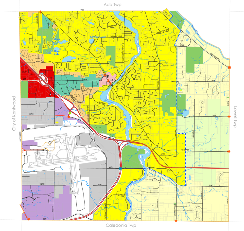
Community gateways have been identified to help promote Cascade Charter Township as a destination, as well as to develop the identity of the main commercial corridors where residents and businesses interact and relate. These gateways could include signage, monuments, landscaping, boulevards, or a combination of all, and may be used to announce community events, to promote local businesses, and to beautify and unify the corridor. Local businesses may sponsor a gateway. Gateways are located at Township boundaries along major roadways, as well as within the Cascade Village area and east of the I-96 interchange at 28th Street.
Redevelopment Sites: Potential redevelopment sites which were identified during this planning effort include the Thornapple Centre shopping complex as well as properties immediately adjacent to the Thornapple River at the intersection of Cascade Road and Thornapple River Drive.